
Kelley Fire threatens Baumgartner Campground
The Kelley Fire grew to 15,700 acres by press time Tuesday morning. Baumgartner Campground was in the bullseye of the fire's advance, which had at least burned to the edge of the popular recreation area, but it's exact status was not immediately known.
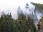
The fire is burning largely in rugged terrain, making it difficult for the 689 firefighters assigned to the blaze to fight it. The fire is less than seven miles to the southeast of Featherville and is only 10 percent contained.
The fire made a big run and spotted across the South Fork Boise River near Jumbo Creek Monday.
The fire continues to make moderate upslope runs, with group tree torching and short-range spotting (throwing embers out to start fires in advance of the main fire line).
A few fingers of fire have crept down toward the river in the Deadwood Creek area.
The fire also has pushed east about a mile and a half south of the Big Hole.
Air Resources now have a portable batch plant on site for retardant, which enables the helicopters to make more accurate, effective retardant drops right where the fire crews need them. The retardant drops are not only more accurate than the large aircraft retardant drops, they have quicker turnaround times, Forest Service officials said.
A closure order has been issued for the Kelley Fire. The order closes the South Fork of the Boise River Road #227 from the Forest Boundary near Featherville, East to Skeleton Creek, then South to Lime Creek Trail. The closure includes Baumgartner Campground.
One firefighter was injured last week when he was hit on the head by a falling tree limb. Although he was taken by LifeFlight from Pine, his injury was not considered serious.
Because so much mountain terrain has been charred this year, the rainfall that was supposed to arrive Monday through Wednesday (today) was causing serious concern among land managers for the possibility of flash flooding. With little or no vegetation and in some cases soil baked to the consistency of concrete, much of the moisture that falls in the mountains will be running downhill, causing flash floods, blocking culverts with debris and damaging roads. Anyone driving in the area is expected to use extreme caution.
Meanwhile, the threat to Atlanta from the south flank of the Little Queen Fire has been mitigated.
The Elmore County Sheriff's Office has announced that both the James Creek Road (FS 126) and the Middle Fork Road (FS 268) were open to public traffic beginning Saturday, Aug. 31, at 2 p.m.
The roads had been closed due to activity associated with the fire and for the safety of the public and firefighters.
Those driving the Middle Fork Road are asked to use extreme caution due to potentially heavy fire traffic leaving the area.
Travelers using the Middle Fork Road between Weatherby airstrip and Atlanta must stay alert, drive slow, and watch for potential hazards from rolling rocks and burning material as well as trees falling across the road.
The opening of the two roads in the Atlanta area is a modification of the general closure order in the area. In general, most roads and trails in the area remain closed.
Structure protection measures have been removed from the Atlanta area.
Hose, pumps, sprinklers and water tanks have been removed from Atlanta and small trenches used for road crossings of hoselays are being repaired.
Due to the rugged terrain on the remaining flanks, and the location within the Sawtooth Wilderness, action on the rest will be taken only when necessary and safe to do so. Only 69 personnel remain on the fire, which has burned 26,500 acres as is 20 percent contained.
The Elk Complex Fire, which has burned more than 132,000 acres, is now 100 percent contained and most firefighting efforts are focusing on patrol and mop-up of any heat that poses a threat to the containment lines or structures.
The 150,000-acre Pony Complex fire also is 100 percent contained and essentially is out except for some smoldering areas.
Closure areas have been modified for those two fires, but essentially most trails and anything except main roads are still closed. Even some of the better roads in the Trinity recreation area remain closed. Check with the local ranger office before driving in those areas and obey all signs posted in the burn areas.
A Burned Area Emergency Response, or BAER, team is assessing watersheds within the burned area for possible short term treatments such as seeding and mulching to protection soils and streams. Following its final report, expected some time next week, the closure areas are expected to be significantly modified or lifted.