
As older fires come under control, new fire breaks out near Atlanta; evacuation ordered
As fire crews bring the Pony Complex and Elk Complex fires under control, a new fire -- the Little Queens Fire -- six miles northwest of Atlanta, has prompted another major forest area closure and another mandatory evacuation.
A mandatory evacuation order for Atlantahas been issued by the Elmore County Sheriff's Office. There are 39 full-time residents of the remote mountain community. A public meeting will be held at 11:30 a.m.at the Atlanta Fire Station to discuss the current situation..
The fire was discovered in the Sawtooth Wilderness area Saturday by Forest Service air attack personnel flying over the area. The fire is believe to be human-caused.
As of Sunday the fire, about six miles from Atlanta, was estimated to be 1,000 acres in size and rapidly growing, moving away from the town, but Monday morning it changed direction and headed south, roughly toward Atlanta.
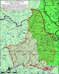
Many old fire burns exist in the area, which may help check the fire's progress, Forest Service officials said. The Forest Service also issued a closure order for portions forest around Atlanta (see map).
The closed area within the Boise National Forest is generally bounded by the Middle Fork Boise River Road (Forest Road 268) from Atlanta heading west to the junction with the Swanholm Road (Forest Road 327) then north to Trail 057 then east to Forest Road 312 until it meets the Sawtooth Wilderness Boundary, and then south along the Wilderness boundary to Forest Road 205 at its junction with the Middle Fork Boise River Road.
The Middle Fork Boise River Road and Swanholm road are open for public use, but areas immediately inside the perimeter and the remaining roads and trails are closed to public use.
Detailed maps and the specifics of the Forest Closure Order can be located at www.inciweb.org.
Meanwhile, fire activity on the other fires in Elmore County has been reduced considerable. The Elk Complex Fire has successfully been steered into the previous year's Trinity Ridge burn, which has allowed evacuated residents to return to Pine and Featherville.
The Elk Complex Monday morning is estimated at 127,000 acres and is 55 percent contained. The target containment date has been advanced from Oct. 1 to Aug. 31.
Crews were planning limited burnout operations on the northwest flank in order to complete the tie-in with last year's Trinity Ridge burn.
Equipment is being pulled out of the Pine/Featherville area to be released for reassignment to the Beaver Creek fire.
The Elmore County Sheriff's Office reopened the Pine-Featherville Road and Anderson Dam Road to residents only on Sunday. Proof of residency is being required for anyone entering the area. Residents are urged to use caution in the area as fire personnel and equipment are still present throughout the community. All power was restored to Pine and Featherville Sunday.
Fall and Lester Creeks residents were escorted back into their neighborhood over the weekend by Elmore County Sheriff's deputies. Approximately 45 vehicles were guided into the area that was burned. That was the area with the greatest damage. Most of the 38 homes that were destroyed in the fire were burned in that area.
The Pony Complex Fire is now estimated at 150,00 acres and is 90 percent contained.
The fire is in the mop-up and monitor stage on all flanks except for the northwest flank from Blacks Creek north to the South Fork Boise River.
Crews were able to secure a critical piece of line on Blacks Creek Sunday.