
UPDATE: Feathervile residents allowed to return to homes
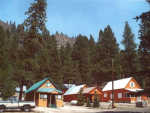
The evacuation order for residents from Featherville to Paradise was areas lifted Sunday.
To limit impact to ongoing fire suppression activities, RESIDENTS ONLY may return to the area with proof of residency and identification
The Elmore County Sheriff has determined that due to ongoing firefighting activities, only residents may return to the Featherville area. Residents must provide proof of residency and identification. Call the Elmore County Sheriff's Incident Command Post in Featherville at 208-590-3845 for additional information.
Residents also can stay informed by attending daily community meetings at 10:30 a.m, at the Pine Senior Center.
The public is reminded that all recreation areas are still closed by order of the Boise National Forest and no one will be allowed to enter the area towing RVs, ATVs or other equipment. Checkpoints manned by the National Guard are still in place and all residents must show ID and proof of residence.
Areas below Anderson Ranch Dam to the Fall Creek Lodge are are unaffected by the closure order, but hunters are reminded much of the area is closed by the Boise National Forest due to the fire. Access to many trails and forest roads is closed and barricaded.
Elmore Sheriff Deputies are patrolling the areas and may issue citations to anyone violating the Road Closed signs and barricades.
The public is reminded that all recreation areas are still closed, by order of the Boise National Forest, and no one will be allowed to enter the area towing RVs, ATVs or similar equipment.
Checkpoints manned by National Guardsmen are still in place and all mountain residents must show ID and proof of residence.
Burnout operations on the Trinity Ridge Fire in the Featherville area are almost complete, with crews holding and improving burned out areas around the community. Crews there are mainly removing equipment and mopping up containment lines. Firefighters will continue to patrol the area for spot fires and hot spots, which often can be seen burning at night.
Unified Incident Commanders are confident the defensive barriers around the town of Featherville and the Pine-Featherville corridor are secure.
Returning residents should be aware, that there will continue to be hotspots within the interior of the fire and they will likely be visible at night. Fire crews will remain on the fire lines and until the fire is contained. Crews will continue to mop up around Featherville over the next few days, a process of extinguishing burning materials near control lines.
Rehabilitation of the disturbed area along the west edge of Featherville is progressing.
Crews are continuing to construct a line from Green Creek Lake east to Wagontown Road, and from the area near Big Roaring River Lake to the 2006 East Roaring fire scar.
Crews in Rainbow Basin are building direct firelines and taking advantage of places where the fire has burned into natural barriers.
Good progress has been made as firefighters prepare the Middle Fork Road in the event the fire backs toward the Middle Fork Boise River.
Three Hotshot crews in the Sheep Creek and Big Five Creeks will directly attack the fire in the Sheep Creek area today.
The contingency line from Thorn Creek Butte to Rabbit Creek Summit has been completed.
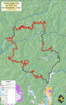
The area closure around the fire remains in effect. Details are on Inciweb at http://www.inciweb.org/incident/article/3088/16582/. A map of the Closure can be found at this link: http://inciweb.org/incident/map/3088/2/.
The fire's movement toward the Middle Fork Boise River was slowed Sunday by helicopter water drops, which allowed crews to directly attack the fire in Sheep Creek.
Crews are continuing to prepare the Middle Fork Road in anticipation of fire growth by removing vegetation adjacent to the road. Crews continue to construct a contingency line from Thorn Creek Butte to Rabbit Creek Summit using dozers and brushers to establish a fuel break.
The 71-acre spot fire north of the North Fork Boise River near Barber Flats is 90 percent contained with full containment expected later today.
Construction of a control line continues from Green Creek Lake to the Trinity Mountain Lookout area. To the east of Green Creek Lake, crews will be directly attacking the fire aided by helicopter drops. Crews will be backhauling equipment out of the Dog Mountain area today.
Fire crews have able to turn some portions of the fire into old burn areas where fuel is limited, thus slowing its movement in some critical areas.
The fire has not crossed the North Fork of the Boise River and remains over five miles south of the Deer Park area.
The fire is slowly burning roughly toward Idaho City and has reached within ten miles of Atlanta, at the Hermeda mine site.
On the western flank, firefighters are taking advantage of natural features, such as rocky ridgetops and areas of sparser fuels to build a line between Trinity Mountain and Sheep Mountain.
The Trinity Ridge has burned 145,000 acres (226 square miles) and is now considered to be 43 percent contained. Some areas are expected to burn until snowfall arrives in October, however.
A total of 1,249 Forest Service firefighters from 28 fireline crews, 52 engines, five dozers and 23 water tenders are fighting the fire, which is slowly advancing around most of its perimeter.
It has cost more than $32.9 million to fight the fire so far.
There have been eight firefighters injured, although none seriously so far (one was hospitalized overnight). Four structures and eight outbuildings, mostly belonging to the Forest Service, have been lost.
The fire began Aug. 3 when a private all-terrain utility vehicle caught fire along a remote road of Trinity Ridge.
Evacuations are still in place for Dutch Creek, Swanholm, Weatherby and Queen River campgrounds. Many roads are currently closed, including:
* Road 227 at the county line east of Baumgartner Campground (the campground is closed).
* Intersection of Highway 20 and Forest Highway 61 (Pine-Featherville Road).
* Intersection of Lester Creek Road and Lake Creek Road.