
Trinity Ridge Fire closure area expanded
Due to the Trinity Ridge Fire continual growth, an area closure has been expanded in the Boise National Forest. The new closure doubles the area just implemented on Thursday, Aug. 9, from approximately 300,000 acres to 563,000 acres.
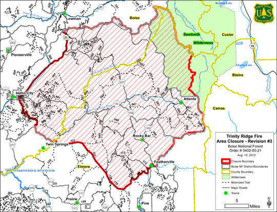
The approximate area affected is south of Lowman, east of Idaho City, north of Featherville and west from within a western portion of the Sawtooth Wilderness.
The fire, which started last Friday, has moved 7 miles, with 4-5 of those miles in one day. Yesterday it jumped the Middle Fork Boise River and is established near the Swanholm Creek drainage at the bottom of steep slopes, dense forests and very dry conditions. Forest officials are very concerned with the potential of rapid growth due to the very dry forest conditions and having recreationists scattered throughout the forest with potential limited exits or notification.
The closure area is within the following boundaries:
The Trinity Ridge Fire Closure Area (including all roads and trails within the fire area) is described as beginning near Featherville, ID at the junction of County Road 61 (AKA. Pine/Featherville Road) and National Forest System (NFS) Road135, located at Township 3 North, Range 10 East, Section 10, then continuing East along NFS Road 227 to the Boise National Forest and Sawtooth National Forest boundary, located at Township 3 North, Range 10 East, Section 11, then continuing Northerly along the Boise and Sawtooth National Forests boundary becoming the Boise National Forest and Sawtooth Wilderness boundary to the Middle Fork of the Boise River, located at Township 6 North, Range 12 East, Section 29, then continuing northeasterly along a ridge to the summit of Greylock Mountain at Township 6 North, Range 11 East, Section 24, then continuing along the ridgeline north to the summit of Blizzard Mountain at Township 6 North, Range 11 East, Section 12, and then continuing north northeast along the ridge to Plummer Peak and the Elmore County and Boise County line at Township 7 East, Range 12 East, section 8, then following the county line to the Idaho City RD and Lowman RD boundary at Township 8, Range 10 East, Section 10 and then continuing along the Idaho City RD and Lowman RD boundary westerly to Highway 21 at Township 8 East, Range 7 East, Section 15, then continuing due South to NFS Road 304 located at Township 6 North, Range 5 East, Section 25, then continuing along NFS Road 304 to the Mountain Home RD and Idaho City RD Boundary located at Township 5 North, Range 6 East, Section 28, and then following the District boundary southeasterly to NFS Road 268 located at Township 4 North, Range 7 East, Section 18, and then continuing along NFS Road 268 northeasterly to a point due North of NFS Trail 122 (AKA. William Pogue National Recreation Trail) located at Township 4 North, Range 7 East, Section 8, then continuing South across NFS Road 327 to the trailhead of NFS Trail 122, then continuing Easterly along (and including) NFS Trail 122 to the junction of NFS Trails 122 and 123, located at Township 4 North, Range 8 East, Section 18, then continuing Southeasterly along (and including) NRS Trail 123 to the junction of NFS Trails 123 and 125, located at Township 3 North, Range 8 East, Section 11, then continuing Southeasterly along (and including) NFS Trail 125 to the junction of NFS Trail 125 and NFS Road 129 (AKA. Upper Lava Mountain Trailhead), located at Township 3 North, Range 8 East, Section 13, then continuing Southerly along (and including) NFS Road 129 to the junction of NFS Road 129 and NFS Trail 176 (AKA. Bear Hole Trailhead), located at Township 3 North, Range 9 East, Section 30, then continuing Southeasterly along (and including) NFS Trail 176 to the junction of NFS Trails 176 and 172, located at Township 2 North, Range 9 East, Section 3, then continuing Northeasterly along (and including) NFS Trial 172 to the junction of NFS Trail 172 and NFS Road 183, located at Township 3 North, Range 9 East, Section 23, then continuing Northeasterly along (and including) NFS Road 183 to the junction of NFS Roads 183 and 172, located at Township 3 North, Range 10 East, Section 9, then continuing Southeasterly along (and including) NFS Road 172 to the junction of NFS Road 172 and County Road 61, located at Township 3 North, Range 10 East, Section 9, then continuing along (and excluding) County Road 61 back to the point of origin.
The above described area (including all roads and trails within the area) is located on National Forest System lands within the administrative and proclaimed boundaries of the Mountain Home and Idaho City Ranger Districts within the Boise National Forest, Elmore County, Idaho, Boise Meridian.
The Boise National Forest administrative boundary is 2.6 million acres, and forest officials are emphasizing that all other areas in the forest are open for recreation and other forest activities. Further information is available by calling the Fire Information Center at 384-3266, 384-3268 or the Interagency Visitor Center at 373-4007.