
Fire continues to burn in mountains, closures noted
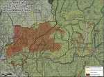
The South Barker Fire above Pine and Featherville, which the forest service is allowing to burn as part of its forest management plan, continued to move east towards Skeleton Creek on Sunday.
The fire was more active than expected over the weekend as moisture did not develop over the fire as predicted. Both individual and group tree torching, as well as short crown runs with some spotting occurred in Jumbo, Weeks and Burnt Log Creeks. The fire has not moved into the bottom of Skeleton Creek.
Crews will be working on the southern perimeter of the fire in anticipation of the fire moving towards the southwest.
The Johnson 2 fire, located on the ridge above Johnson Creek, just south of the Sawtooth National Recreation Area has increased in fire activity.
The fire is approximately 30 acres in size and is being managed by Svalberg's Interagency Fire Use Management Team as a Wildland Fire Use fire in conjunction with the South Barker Fire.
On Sunday afternoon, a public meeting was held for private property owners in the Upper South Fork Boise River area at the Methodist Camp. Personnel from the Fairfield Ranger District and the Fire Use Management Team provided presentations to residents about the progression of the South Barker Fire, current and predicted fire behavior and effects, and fire operations.
The area closure on the Fairfield Ranger District, Sawtooth National Forest, remains in effect.
As soon as it's safe for people to reenter the area, forest managers will reopen access.
Forest Road 227 is closed from Featherville to Big Smoky junction. Forest Road 012 is closed above Big Smoky junction into the Upper South Fork Boise River residential area. Private landowners can still access their property but not Forest Service land beyond their property.
The expanded closure includes Trail 070 along Paradise Creek and all trails to the west.
Those roads and trails lead into the area where fire activity continues.
Contact the fire information office or the Fairfield Ranger District office for more specific details about the area closure and other areas that remain open for weekend recreation.
Additional information can be found on the website at www.inciweb.org and data from the air quality monitor in Pine can be viewed at http://www.satguard.com/USFS/fleet.aspx/