
Roads will reopen to Atlanta Saturday afternoon
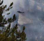
As fire crews begin to get a handle on the Little Queens Fire just north of Atlanta, the Elmore County Sheriff's Office has announced that both the James Creek Road (FS 126) and the Middle Fork Road (FS 268) will reopen to public traffic beginning Saturday, Aug. 31, at 2 p.m.
The roads have been closed due to activity associated with the fire and for the safety of the public and firefighters.
Those driving the Middle Fork Road are asked to use extreme caution due to potentially heavy fire traffic leaving the area.
Travelers using the Middle Fork Road between Weatherby airstrip and Atlanta must stay alert, drive slow, and watch for potential hazards from rolling rocks and burning material as well as trees falling across the road.
Crews made good progress with mop up and securing the containment line on the south flank adjacent to and near Atlanta, as well as to the west along Middle Fork Road.
Hose, pumps, sprinklers and water tanks have been removed from Atlanta and small trenches used for road crossings of hoselays are being repaired.
Fire crews continue to secure and mop-up the south flank of the fire adjacent to and near Atlanta. The east and west flanks of the fire will continue to be monitored for fire activity. Suppression action utilizing helicopter water drops will be taken if necessary.
On Friday the fire still had 195 firefighters assigned to it. It had burned 23,500 acres and was considered 20 percent contained.
Fire behavior was low and included creeping, surface fire and group tree torching.

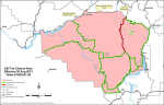
The opening of the two roads is a modification of the general closure order in the area. A map of that closure area is included on this page.
The Kelley Fire, burning seven miles southeast of Featherville, grew by 400 acres to just under 1,000 acres by Friday due to increased winds Thursday.
The fire, burning in steep, rugged terrain, is 5 percent contained. Ground resources will continue to construction both direct and indirect firelines and aerial resources will support them with bucket drops.
The fire grew over 400 acres yesterday afternoon
The fire is moving north across the West Fork Kelley Creek Trail and spotting northeast across #50 Kelley Creek ATV trail (also known as the Iron Mountain Trail).
Five engines are in place and more engines are enroute for structure protection north of the fire along the South Fork of the Boise River.Aerial resources will continue to support the ground troops with bucket drops.
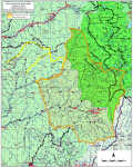
A closure order has been issued for the Kelley Fire. The order closes the South Fork of the Boise River Road #227 from the Forest Boundary near Featherville, East to Skeleton Creek, then South to Lime Creek Trail. The closure includes Baumgartner Campground.
One firefighter was injured earlier in the week when he was hit on the head by a falling tree limb. Although he was taken by LifeFlight from Pine, his injury was not considered serious.
The Elk Complex Fire, which has burned more than 131,000 acres, is now 95 percent contained and most firefighting efforts are focusing on patrol and mop-up of any heat that poses a threat to the containment lines or structures.
The Boise National Forest has revised the boundaries of the Elk Complex Fire closure area. See the map on this page.
A Burned Area Emergency Response (BAER) team is assessing watersheds within the burned area for possible short term treatments such as seeding and mulching to protection soils and streams. Following its final report, expected some time next week, the closure areas are expected to be significantly modified or lifted.