
Mayfield area added to evacuation area
Additional evacuation orders were put in place Saturday afternoon as a pair of range fires continued to grow north of Mountain Home.
People in the Mayfield area, including the communities of Regina, Baseline and Indian Creek, were urged to evacuate as the Elk Complex Fire continued to move closer to these areas.
Meanwhile, those living in Prairie and the Fall Creek Road area remain under a mandatory evacuation with the fire destroying at least one structure in this area earlier in the day. In addition, evacuation orders were issued for the areas around Anderson Dam Reservoir up Fall Creek Road to Ice Springs Campground and east to Lester Creek Guard Station along with the Danskin fire lookout.
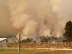
The latest reports indicate that the Elk Complex Fire has grown to more than 40,000 acres. It was moving north and northwest around Prairie and was approximately four miles west of Pine and Featherville.
According to a spokesperson with the Bureau of Land Management, the Elk Complex Fire was jumping across the South Fork of the Boise River during the day at multiple locations, including Cow Creek and Danskin Bridge.
Specially equipped helicopters and C-130 transports have flown multiple missions throughout the day to drop fire retardant to help contain the blaze.
Meanwhile, the Pony Complex located below the South Fork of the Boise River is moving to the north and northwest toward Blacks Creek Road and the South Fork of the Boise River. The fire remains very active, with crews working to construct fire line where accessible.
Numerous structures and outbuilding are currently threatened by both fires with heavy smoke and ash being reported in Garden Valley, Idaho City and the Boise Foothills due to both fires.
Meanwhile, Idaho Power is working to repair miles of downed powerlines in the area.
The following road closures remain in effect:
- Blacks Creek Road off I-84 at the Ada County and Elmore County line
- Indian Creek Road off I-84 at exit 71
- Anderson Ranch Dam south on the Dixie Creek Cut-off to Highway 20
- Prairie Road and Cow Creek Road heading north from Highway 20
Boise National Forest officials also initiated a large area closure that extends from the Pine/Featherville road on the east, Forest Road 172 and the William Pogue Trail to the north, the Middle Fork of the Boise River to the Arrowrock Reservoir extending south along the forest boundary to the north side of Anderson Ranch Reservoir.
However, the Anderson Ranch Reservoir, the Middle Fork of the Boise River Road and the Pine/Featherville Road is open to public use.
The American Red Cross moved its evacuation shelter to the Our Lady of Good Counsel Fellowship Hall in Mountain Home for residents that were displaced due to the fires.
Stage I fire restrictions remain in effect including using a campfire outside of an agency designated recreation site until further notice. Details are available online at www.blm.gov/id.