
Class hones map-reading skills
Students at Richard McKenna Charter High School gained a new appreciation for maps and navigation tools through a new class that honed these traditional skills.
The school's map skills class took students back to the basics of reading various types of maps and how to use a compass with less emphasis on computer-based technology. It also helped them translate and interpret various lines and symbols included in the myriad of maps people regularly use in different careers.
"I wanted to do a project to model landscapes and show kids how topographic maps represent real earth landscapes," said Todd Thorn, who taught the inaugural class.
Students like Shauntay Schroeder were initially reluctant to take the class but quickly grew to enjoy the lessons. While her father is "really big on reading maps," the teen had no idea how to read them before she started the class.
The eight-week course started by introducing students to "mental maps" -- a process in which the teens used buildings and physical landmarks in town to guide them from Point A to Point B. That lesson helped illustrate one point the students didn't expect.
"They know how to get from their house to school or to their friend's house, but they have no idea what the street names are in town," Thorn said.
In fact, a few of them didn't know that Haskett was the name of the street next to their school, he added.
"I've lived here my whole life and I don't really know any of the streets in town," said Ladawne Elder, one of several students that participated in the map class. "I know my street and a couple of other ones, but that was about it."
"I'm personally terrible at remembering directions from a given starting point to wherever I'm going," said fellow student Maxwell Snoey. "I have a few places that I know because of the landmarks around places like Boise."
But mental maps are only useful if people are familiar with the cities they normally visit. For students like Elder, places like Boise are perfect places to get disoriented, especially with all the one-way streets in the downtown area of the state capitol.
"I get so lost in Boise," Elder said.
While advances in computer technology can help people plot the quickest or shortest route from place to place, the technology is far from fool-proof, Thorn said. He remembered one instance during a recent vacation to Hawaii where he relied on the Global Positional System navigation device built in his cell phone to find a hotel on the island.
"It was dark and we were using the GPS on my phone," Thorn said. "But it totally misled us. It ended up putting us seven miles from where (the hotel) actually was."
That experience demonstrated that satellite-aided navigation tools are not fool proof.
"It's not the oracle of knowledge," Thorn said.
"They're a lot better for general directions," Snoey added.
While people can get around town or parts of southern Idaho without much trouble, the map-reading skills these teens learned will help them tackle more complicated challenges, including long-distance road trips.
The ability to not only read a map but to chart the best routes will help teens like Schroeder, who plans to visit members of her family, especially those who live out of state.
"I used to live in Nevada, and if I ever wanted to drive there on my own I can just find which route to take and just follow it on a map," Elder added. "I would have a better sense of direction."
But those skills are not limited to navigating roadways. Schroeder's family enjoys going on hiking trips in the nearby mountains, which often requires them to navigate along the safest and easiest paths. Normally, her dad tackled that duty.
"I always knew that a compass pointed north, but I never knew how steep a hill was," Schroeder said. The map skills class gave her new insight into that facet of off-road navigation.
"I'm thinking that the next time we go hiking that I would be able to do the map reading," she added.
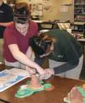
The final project of the class required the students to research volcanic islands and create their own fictitious version. It started with them drawing out a scale map of an island on paper with different colors representing different terrain elevations.
The students were then required to translate that map into a three-dimensional model that included a scale depiction of every valley, mountain peak and river basin.
Using clay as their building material, the teams sliced the blocks into horizontal sections representing elevations of 100-foot increments. After some needed trimming, these sections of clay were then stacked on top of one another before they were blended together. That work alone took a few days.
"The hardest part was actually cutting everything (apart)," Elder said.
Looking back, the students admit they gained a new appreciation for map-reading skills, which they added will help them throughout their lives.
"I never knew how to read a map before this class," Elder said. "Now I actually know where I'm going."